
Cataract Canyon is a 41 mile stretch of the Colorado River that is from just below the confluence of the Green and Colorado Rivers. It is both notorious and forgotten.

Topo Map with notes from George Simmons
In the late 1800 through the 1960s, Cataract Canyon’s rapids proved to be challenging to all parties who chose to try to navigate this stretch of river.

Portage operation around a particularly bad place in a rapid (the Big Drop) in Cataract Canyon of the Colorado River - Discharge at this time was 65,000 cfs courtesy of the USGS Salt Lake City

Wrecked Boat in Cataract # 2, USGS Salt Lake City
In 400 feet of descent, there were as many as 55-60 rapids through this stretch of river. Early river runners in wooden boats portaged many of these rapids. Even with great care, many wooden boats were stuck, flipped, holed, destroyed, or lost. This earned Cataract a nickname: The Graveyard of the Colorado.
And then this happened:

Glen Canyon Dam Site w coffer dam 1959 Gregory Crampton P0197n37a_02_001, cropped and enhanced
Special Collections, J. Willard Marriott Library, The University of Utah

Glen Canyon Dam construction July 14 1961 Gregory Crampton P0197n04_01_001, cropped and enhanced
Special Collections, J. Willard Marriott Library, The University of Utah
Glen Canyon Dam construction, completion, and impoundment of water put a new slant on the nickname of “The Graveyard of the Colorado”. Even though the Dam was 186 miles downstream, when the new reservoir was full, it would back water up all the way into Cataract Canyon. It would drown 27 miles of Cataract Canyon (65%) and up to 28 of its rapids.
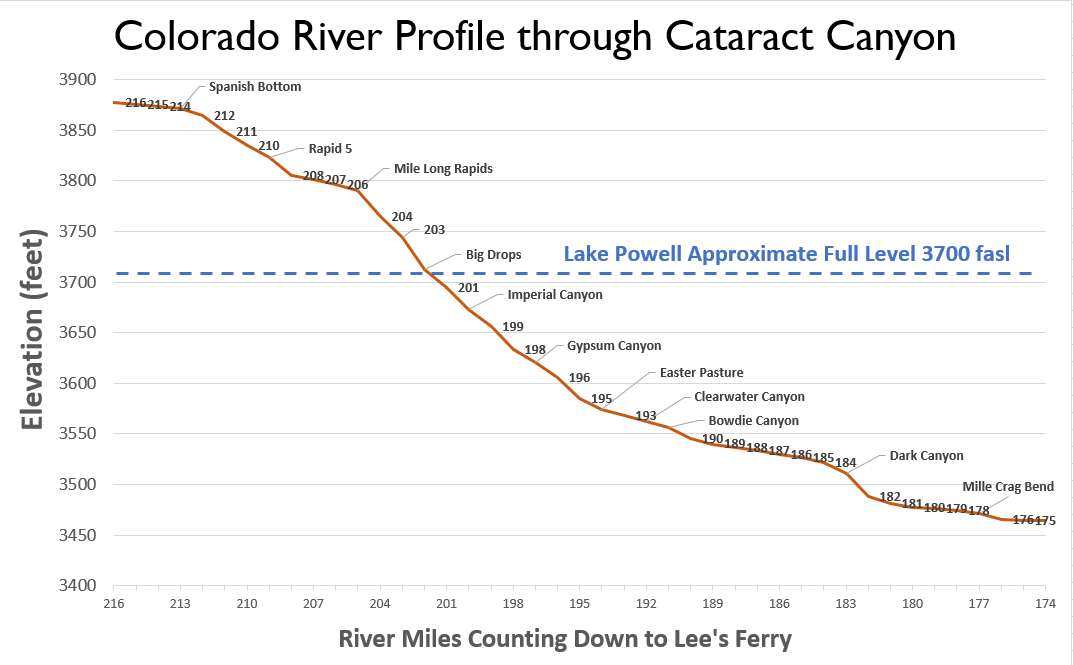
River Profile Through Cataract Canyon showing the level of Lake Powell
Over the 1970s and 80s, the new reservoir slowly filled. In the early 80s it reached and almost breached this new dam in 1983. From 1984 and on, the reservoir would never again reach this high mark. However, its effects were starting to take hold in many ways.
The Colorado has always been known for its big muddy waters

Dark Canyon Rapid, Grant Reeder, 1964, courtesy of Stuart Reeder
Draining the entire Colorado Plateau doesn’t consist of a river flowing solely of water. The Colorado was named after its ability to carry water that is the color of red. When a industrial 550 foot tall structure is placed to capture and control its water, there is another factor that shows up at the table - sediment, the mud, the color of the river. When the current of this river is stilled, and its water is impounded, the sediment drops out. For what was middle to lower Cataract Canyon, this meant it was buried in reservoir caused sediment.

River Delta Profile , Mussetter & Morris 2001